
A month on from when I was first able to gleefully say I was a ‘pilot’, I’d clocked up over 40 flights and 17 hours air-time, and I definitely felt a lot more experienced for it. I needn’t worry about being overly-cocky as the past week had seen my confidence in the air take a big hit after having a fairly scary collapse not far above launch. I knew tensing up every time I hit the slightest ripple in the air wasn’t going to help my skills progress and hoped that, with a few more flights in lightly active air, I’d be able to show myself that I could control the wing in conditions that had previously got the better of me.
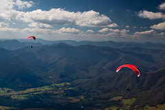
Soon enough, things started feeling a bit more natural, and I finally felt comfortable enough to try something that had been nagging me for weeks: a reverse-launch off Mystic. It surprised me just how easy it was, leaving me wishing – as I was whisked into the air before completing my first step forward – that I’d tried it sooner. Now well into April, having missed some of the best flying of the year because I was working every hour I could at the Brewery, I was definitely ready for some soaring again and couldn’t wait for the start of the cross-country course Ted invited me on. Frustratingly, the first few days weren’t quite good enough to make a stab at a cross-country flight, but that probably worked out for the better, as they were unstable enough to help me re-build my confidence in active air, and I still got a few flights that tipped over the hour mark. I had fun trying to do some semi-formation-flying with Bill – an instructor who’s taken some great photos from the air – giving me more practice with my camera in the air as well as finally getting some decent shots of me flying.
Each morning Bill would talk Ben, Charles and I through a plan for the most likely cross-country option for the day ahead, whizzing round Google Earth pointing out routes, thermal trigger points, landing sites, no-landing sites, as well as showing us how to interpret various weather forecasts. Today our likely target was Harrietville – a town 15km along the Great Alpine Road from Bright – and, as we caught a strong climb above Mystic, it was looking like it was going to be the day we’d finally break away from the comfort of our training ground. First, led by Bill, we checked out an alternative route, heading north along the ridge from Mystic, but doubled back in the unrelenting sink and topped up our height over Mystic again. This time Bill headed east across the Wandiligong Valley to the Reliance Ridge, with Ben and I soon following at almost identical altitudes, side-by-side but for a hundred metres or so to maximise our chances of finding lift. Charles followed shortly after, having eeked out a few extra metres height from the thermal we’d all been in.
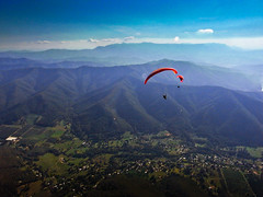
One of the great experiences in paragliding is the hands-off gliding time: now out of the reliable lift that Mystic offered, all I could do was sit back, tuck my hands in my jacket to warm them up again, and think about just how awesome it was to be floating effortlessly above the stunning valley below. Over Reliance Ridge we got our first climb quite quickly, recovering most of the height we’d lost crossing the valley, continuing south along it. I didn’t envy Charles, who just missed out on the lift that we’d used and had to scratch along the ridge below us, a position that wasn’t nearly as comfortable as where we were. In what must have been a pretty good effort, he kept ‘up’ with us as we soared along the ridge, now reaching the tree-carpeted-bowl that stood, dauntingly, between us and our target. Somehow, all of us struggled to maintain height, never-mind find the lift that we desperately needed to make a crossing of the bowl possible. This was bad enough for Ben, Bill and I, who were high, but for Charles it was the end of the flight and he had to bail out on the road near Smoko.
With so many places where there could be lift, it was frustrating to be almost aimlessly floating around, but finally, after flying over a spot I’d covered a minute earlier, my wing banked and I hooked round into a strong thermal. Bill and Ben headed for the lift, but Ben couldn’t make it with his height and had to follow Charles to the road, while Bill soared past me and we both headed across the bowl. This was a bit daunting, nothing but trees all around me, a ridge that presented its self like a wall in my path, and Bill calling over the radio, slightly concerned at my apparent height. We’d talked about the bowl in the morning, discussing what would be a safe minimum height to start crossing at, and I’d started at almost exactly that, so all I could do was sit back, use some speed-bar to cut through the steady sink and keep an eye on the limited bail-out options I had.
Approaching the ridge only a few hundred metres above it, Bill, who’d lost some height to join me and make sure I was flying safely, guided me round the edge of the ridge, avoiding the highest part, giving the most impressive opening view of a village I’d never even been to before. Gliding round the ridge, so low that we were almost in shade from the late-afternoon sun, the ridge fell away and opened up a stunning view of Harrietville, basking in the last of the day’s light. Now safely on glide to the landing site, I grabbed my camera, not wanting to miss the chance to capture the beauty of discovering a new place from the air.
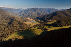
The tension of the last 10 minutes gave way to relief, and the realisation that I’d made it: my first cross-country flight. There was a moment, as I followed Bill down to land, where I was a wee bit nervous again as the field had a small burn on one side, cows on the other, and power lines running along another edge, but following Bill’s lead and doing some S-turns to lose some height, I made it. Two hours ago, I’d jumped off and floated away from the comfort of my training hill: now I was over 10 miles away in a village I’d never seen before, watching the setting sun cast its last golden rays over the mountains that surrounded me. If ever there was a way to explore the world, this was it.