Mount Buffalo

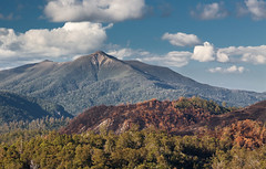
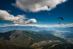
For over a month I’d been soaring over Mystic, using the looming lump of Mount Buffalo to the west to gauge how high I was, but I’d yet to make the mere 25km trip to the mountain. Leanne and Greg thought we could go up there and camp out for a night around their day off – being the owners of the hostel and the jewellery shop, and living in Bright, means they can get away with closing the shop and letting the hostel run its self every Tuesday. As the Tuesday came around, they couldn’t make it, but in their usual super-kind fashion they chucked enough gear in their 4×4 for Crystal and I to start a Polar expedition, and let us drive up to Buffalo ourselves. Seriously, I can’t go on enough about just how lucky I was to stay at their hostel and have them help me in so many ways.

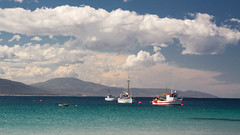
Tuesday came, and Crystal – a Canadian who’d came to pick grapes at Boynton’s winery – and I headed out past Porepunkah, up the Mt Buffalo Road. As with most of Australia’s national parks there are fees for entering and I think it was about $18 for us to take the car in, which made it really surprising that to reserve a camping spot beside Lake Catani only pushed that up to about $25. The drive up is steep and winding: great since I was driving, but the trees blocked out most of the views of the lowlands that fell away around us as we headed to the plateau.

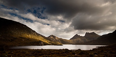
I’d only had my laptop for a week or so and was itching to try some time-lapse photography, now that I had a way of automatically triggering the camera. Lake Catani, surrounded by reeds, and with a few ducks and a canoe floating around in the ever-changing light, was too good an opportunity to miss so I perched the laptop on a rock at the lake’s edge and left the kit doing its thing for about half an hour, while I blitzed through the crisps I’d bought in the name of ’emergency supplies’. The campsite was set a few hundred metres from the lake, and when we found our site we realised the park ranger had given us one of the best spots, sheltered under trees at the edge of the site, with an unrestricted view of the lake. The tent Greg had packed turned out to be a small mansion, possibly visible from space, well, at least the other side of the lake.

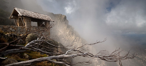
Next we headed to The Horn – I didn’t know anything about where the best sights on the massif were so was trusting Crystal’s experience – first reaching the lookout, perched on the edge of a cliff with mist washing up the face. Thoughts of the Himalayas came to me as parts of the rocky landscape revealed themselves but for moments through the waves of mist. Up at the peak, the view was impressive, albeit over a landscape that felt anonymous to me as a new-comer to the area. The cloud-base not far above my head was breaking up the light across the plateau in a fairly interesting way so I tried another time-lapse, looking back across the Giant’s Playground to our next stop: The Cathedral.

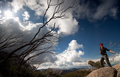
We decided to climb the hill across the road from the Cathedral, as Crystal hadn’t been up it, but got distracted by a huge and precariously-perched rock and the prehistoric-looking landscape behind it, and ended up chilling in the calm sunny afternoon there for a while. We followed a track downhill a little bit and ended at a base of a hill made up entirely of massive boulders, so big I had to leave my camera at the bottom before trying out my pretty non-existent bouldering skills, but I managed to get up far enough to get a nice view over where we’d came from.

We ended up at the Chalet to watch the sunset from the top of monumental drop into the gorge. We were really on the wrong side of Buffalo as the sun was setting over by the Horn lookout, but at least at this side the landscape of the Ovens Valley was much more recognisable, stretching from the Eurobin – where I’d worked on a berry farm – back to Bright and the Mystic Launch. Back at the lake I thought I’d be warm enough with my roll-mat and a few blankets, but about an hour in I had to go back on that plan and get the sleeping bag out before I went hypothermic.

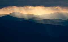
Deciding the view from the Chalet at sunrise would definitely be worth getting up for, we did exactly that and I set up a time-lapse at the hang-gliding launch ramp. The launch ramp is just a 5-meter timber ramp rolling off to the sheer +500m drop to the bottom of the gorge in a ridiculously scary fashion. I tried to stand on it but dared only put one foot on the sloped part of it. While the laptop and old camera were doing their thing, the sun broke through the clouds casting some amazingly strong and focussed rays across the valley, keeping me fixated with the other camera for the next hour. It was good to be sitting in one spot, focussing on one scene, instead of running around from place to place trying to capture as many sights as possible while not really giving any one them the attention it deserved to create a truly decent shot.

I was pretty sure I was rostered on at the brewery for 1pm that day, giving us time to pack up and check out one or two sights on the way back to Bright. I’ve found some brilliant spots, both in Australia and back home, just by taking the more obscure roads, and that thinking led us down a dirt track with the perfect mix of corners and crests to make haring along it really fun. Luckily Crystal seemed to trust my driving along the road that branched off near the snow-clearing station and led to a few walking tracks that led back in the direction of the Cathedral. We didn’t make it as far as we wanted as I was worried about not making it back to Bright in time and it’d definitely be worth a revisit. The worrying was well-justified: getting back to Bright at 11.30 I phoned in to check when I was starting, ’15 minutes’, oops..

Tasmania Day 14: Zeehan & First Impressions of Cradle Mountain

Yesterday was Australia day. Obviously we did our bit as temporary residents of the red island continent and had a few drinks in one of Strahan’s pubs and so next morning I woke up crumpled up under a duvet in the driver’s seat of the car with David beside me. We weren’t feeling too bad, Strahan wasn’t exactly an exciting night out and the burgers we’d cooked at the beach before the pub had been a master-stroke of planning and damage-avoidance. Still, I was a bit confused, seeing as it had been Kevin who’d been in the front of the car with me when I’d fallen into a slightly drunken sleep. Wiping the dripping wet windows cleared that one up though: he’d had the raw deal last night with David sleeping in the back seat behind him and had bailed out half-way through the night to sleep on a bench overlooking the beach. Even with the view of the calm waters of Macquarie Harbour to wake up to, I still can’t say I was envious of that move.. To the humble, grubby backpacker, Strahan is a jewel though, as it’s the only place we found on the island that had free, hot showers so we basked in the glorious steamy goodness one more time before heading north towards Zeehan.

On the road up the coast we hit a viewpoint overlooking the expanse of Henty Dunes, but they were quite far away so it wasn’t all that interesting, letting us crack on to the free bbqs in Zeehan and where we tried to boil pasta for lunch. Overall it was a bit of a failure with at least one of the pans looking more like a pot of starch than spaghetti, oh well. Zeehan felt, like most of the towns in the west, very sleepy with nothing catching our attention and in little time we’d got through it, Rosebery and Tulla, leaving not much between us and Cradle Mountain.

This was more like it, heading back into the highlands of the island, with the promise of seeing some of the most stunning scenery it had to offer. Tomorrow David planned to do the Overland Track – a 6-day, 80km walking trail from Cradle Valley to Lake St Clair – and that was why we were giving him and his bike a lift to the starting point. The information centre was still open when we got to Cradle Valley so David got his bike locked up (he’d have to find a way back up here by road after doing the track). While we had some light I really wanted to get a first glimpse of Dove Lake and The Mountain and, as far as first glimpses go, rolling up to the lake side, catching the last of the low sun breaking through the dramatic and now colourful clouds was just what I needed to get me raring to climb the ominous collection of rocks that loomed in the distance.

Scoping out the place for possible camping spots for the night we realised the place was far too popular and completely devoid of secluded spots suitable for a bit of rock-bottom-budget sleeping, forcing us to drive back out of the park boundary, heading north along the main road in search of side tracks and the likes. Seemingly land-owners were on to our kind long before we arrived, as every possible track off the road had a little ‘private – no entry’ sign nailed to a tree, so we ended up finding a patch of relatively soft ground at the side of the road and made it our home for the night.

Tasmania Day 12: Lake St Clair & More Western Wilderness

Now that I’m writing about Tasmania 4 months after it happened, and I’ve left what notes I wrote about it back in Bright, some of these days’ posts might be a bit vague. It’s funny how much I can forget about what I’ve done on my travels, so quickly after the event – thankfully looking back over my photos helps fill in some of the gaps and dig some almost-forgotten events back up into consciousness.

Waking up to a beautiful morning at the idyllic and dead-silent Ted’s Beach, I wished it was warm enough to risk a dip in the dark tanin-tainted waters of Lake Peddy, since we were back to living without showers again. If it took us little time to get in to the wilderness, it took us even less time to get out again, breaking north across the Derwent River, stopping momentarily at the quaint Ellendale, dominated by a bright white-wash church overlooking a well-manicured graveyard. After another meal featuring the ever-popular indomie noodles and a side of nachos we stopped at Tarraleah – another part of Tasmania dominated by hydro-electric schemes – to witness the rows of pipeline quietly channelling the potential energy stored in nearby lakes to the generating stations tucked into the bottom of the valley.

Next stop was the end of one of the greatest walking tracks in Tasmania – the 80km Overland Track – at Lake St Clair. We walked a little bit of track as part of a much smaller circuit that took us round part of the south-west edge of the lake. On the return leg we branched off along an Aboriginal Culture walk, seeing some beautiful grass-land but not really feeling the information signs that were dotted around. Maybe that’s a testament to the lack of knowledge we have on Tasmanian Aboriginals due to wiping most of them out while trying to colonise the island.

Continuing west on the Queenstown road, we stopped at the Donaghy’s Hill carpark and did the 15 minute walk up the hill, being rewarded by a 360 degree panorama encompassing peaks from the south of Cradle Mountain National Park to the north of the Franklin-Gordon Wild Rivers National Park, made only better by the late afternoon light. As that recommendation of the ranger at Lake St Clair had held true, we checked out Nelson Falls, further along the road, to find them flowing much better than Russel Falls yesterday. Not being totally fenced off by the board-walk, I got right up to the falls and was way happier with the shots I got.

With the sun down and the light fading it was time to scope out our sleeping spot, and with a few camping areas dotted round the nearby Lake Burbury we thought it should be quite easy. The first sight, tucked into a corner east of the lake near the bridge just north of the road, charged a fee but had loads of flat grass as well as showers, not that we were tempted by either. Next we tried a site near a boat-ramp on the west side of the lake, south of the main road, but all pitch-able spots were taken. That left us with a site marked just north of the road so we hunted it down, first driving past the access road as there was no sign. There didn’t seem to be a proper camp area as such, but we passed a number of mobile-homes dotted tucked into every slightly wider part of the road, which didn’t fill us with hope. Where the road ended, and met the bank of the lake, it widened into a rough sloping area that was just about adequate for us so we settled there.

By now it was pretty dark so we left the car lights on while we pitched the tent, then realising, as we tried to start the car afterwards, that we’d killed the battery. I had a fairly good idea how to do a rolling start so we decided not to worry about the small matter of being stuck in semi-remote west-Tasmania with a dead car until the morning. The night sky was brilliant and the landscape quite visible in the short summer darkness, letting me try some of those night shots that almost look like day-light, finishing up with a long exposure that I didn’t wait to see the result of before going to sleep. So, in the morning, I’d find out if my night photography skills were up to much as well as, crucially, those that I had in the art of starting dead cars.

Tasmania Day 5: Douglas-Apsley & Bicheno

Sleeping in the car overnight disposed of our usual morning routine: me putting off getting up for an hour, spending the next couple of hours trying to get Kevin up before the morning was over, then spending the next half hour packing the tent and stuff back in the car. Even if our sleep hadn’t been comfortable, it felt quite novel to wake up and then be ready to drive off 5 minutes later.

Heading south towards the Freycinet Peninsula, we stopped in by Douglas-Apsley National Park and did a 2.7km trail that we thought led to some amazing falls. After walking what felt like at least 2.7km we came back upon the river we’d crossed earlier, except this part was faster, deeper and looked a lot less fun to cross. If there was anything of interest on the other side, maybe I’ll never know, but when we got back to the carpark and re-interrogated the map, we realised the falls were on a different track that would take days to hike. The best view we got was from a lookout that was closed because of landslip, overlooking the bend in river where the shallow river-crossing is.

Bicheno, a small town with a beautiful bay and beach, was annoying as it seemed devoid of free bbqs – something we’d come to rely on to save us using all our camping gas in a couple of days – leaving us hopelessly trying to fry all the stuff we’d bought for a bbq on a useless frying pan, perched aloft a pitiful stove. We eventually ate and retired to the beach for the rest of the afternoon, although the water wasn’t really warm enough for my liking for a swim. It wasn’t far off Coral Bay for beauty though, with clear water and fish swimming right up to shore.

Intending on hitting the Freycinet Peninsula next morning, we took the Coles Bay road and parked up at the River and Rocks campground, not far from the town. I had a seemingly brilliant idea that I would try sleeping across the back seat of the car as I really didn’t like trying to sleep on the almost-but-not-quite-flat front-seats of the car. Doing this, though, meant Kevin couldn’t get his seat quite as flat as normal, and sleeping in the back seat wasn’t nearly as comfortable as hoped, so both had a shocking night’s sleep.